Saturday, September 27, 2014

A "peak" experience. :)

We started our day heading up Pike's Peak highway, then coming down after a few miles when we realized we needed to fill up with gas before entrusting our Jeep to the climb. :) The nearest gas station to Pike's Peak is SIX MILES from the highway entrance, which is surprising since I am sure we are not the first people to want to fill up before making the climb.

The drive up was GORGEOUS! Fall colors (almost entirely yellow aspen) were in full brightness at this higher altitude. We paused at a reservoir with perfect, glassy blue water and a nice view of the summit, still several miles in the distance.

The summit of Pike's Peak is the one with the cloud over the top.


Incredible fall colors!
Pike's peak and fall colors.

It took us around an hour total to reach the summit (with a couple picture-taking stops :) ). Pikes Peak Highway is only about 19 miles, but has a very steep grade and lots of hairpin curves with sheer dropoffs and few guardrails; we were definitely driving pretty slowly! Once we reached the top, I found myself periodically gasping for air, as it was so thin! Since the day was clear, we could see a long way; they say you can see five states on a clear day! We definitely saw Denver's smog cloud hovering north of us.

View from the top of Pike's Peak, facing south.
View to the north from a lookout point close to the summit.

After wandering around the summit a bit and visiting the gift shop, we drove back down Pike's Peak Highway and stopped at a little rock shop (the owner of which had kindly given us directions to the nearest gas station before we went up!), and they had some incredibly weird stuff for sale! (supposedly all real...) Lots of fossils, including mammoth teeth and turtle poop. We bought a stone dish that was made from a stone with shell fossils embedded in it.

headed back into Manitou Springs. We ate a delicious lunch at Suzy Q's barbeque, sharing a pulled pork plate sitting at their outdoor counter, which made for great people watching. After lunch we did a silly tourist thing that I have always wanted to do: we got "old tyme" pictures taken at Olde Tyme Photography. We planned to have me dress as a saloon girl and Gavin as a Native American, but Gavin was uncomfortable with being bare chested besides a small breast plate, so he traded outfits to be a "gambler cowboy." The effect was pretty hilarious. We took several serious and smiley ones where the photographer posed us very precisely, then she had us improvise one silly one and said, "Nobody ever chooses the silly one..."

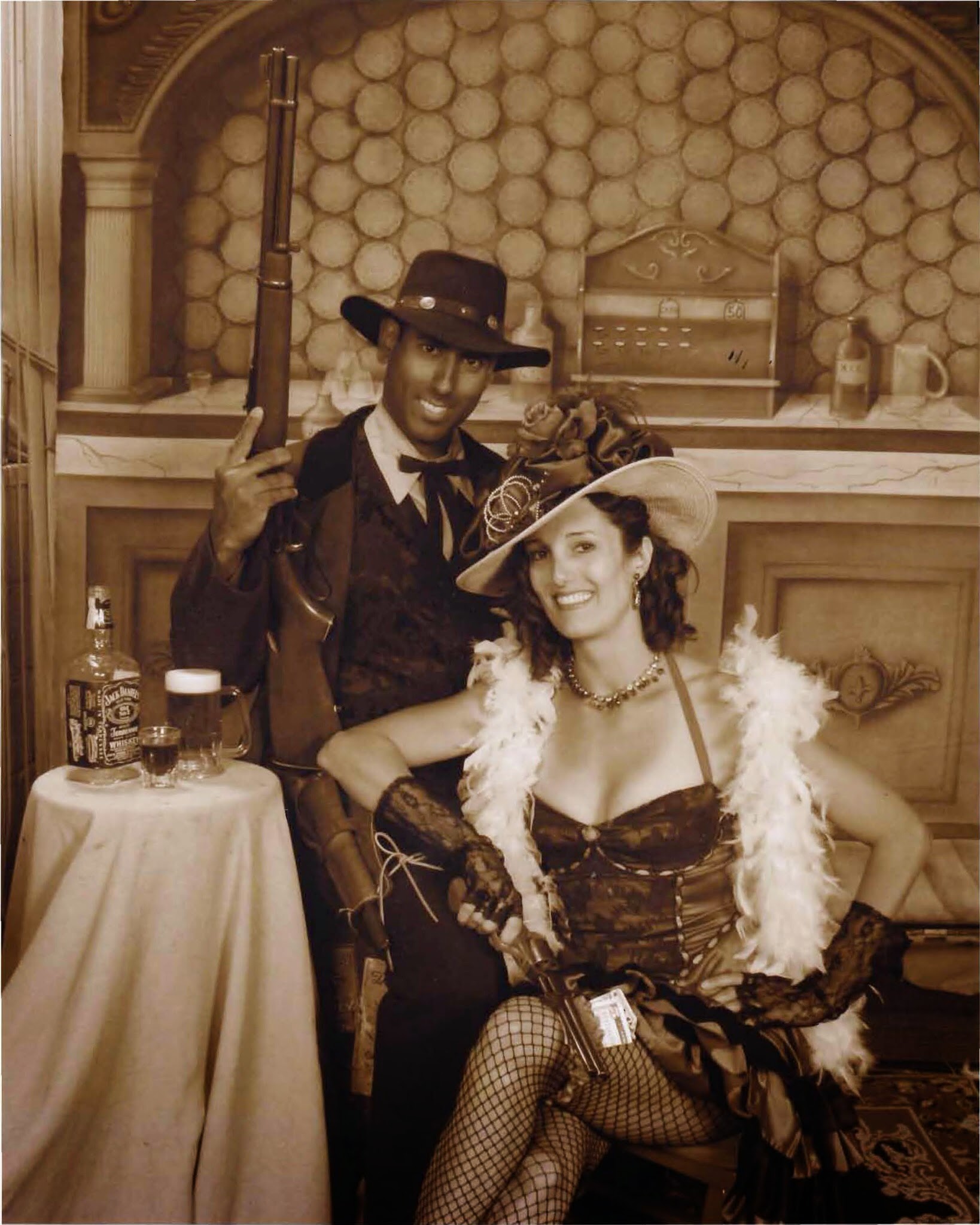
Aw, aren't we cute... :)


But this silly improvised one makes me laugh every time I see it!

While waiting for our photos to get framed, we wanted around and did a little shopping. I ended up buying a coffee mug at an artists' gallery while I of course was willing to spend $20 on because it had a kitty on it. :) We then headed in to Denver to check in to our airport hotel, as we have an early flight tomorrow. We met Gavin's brother, who lives close to Denver, at the Denver Chophouse and Brewery for an absolutely DELICIOUS steak dinner. Then we headed back to our hotel to end our trip with a very short night's sleep.

Though I am not a huge fan of road tripping, being much narcoleptic in cars whether driving or riding, this trip to the Southwest had some amazing things to see and do! Now that we've had a "sampling" of the Southwest, I look forward to going back and spending a bit more time, perhaps hiking down and spending the night at the bottom of the Grand Canyon, spending more time in the crystal clear waters of Lake Powell, white water rafting down the Colorado River, or finally getting to do our hot air balloon ride in Sedona! I look forward to many more adventures in the Southwest!


Wednesday, September 24, 2014

Great Sands FAILS and Royal Ripoff

This morning we out of Pasoda Springs and drove east to the Great Sand Dunes National Park. This was a really lovely part of our drive, as we saw the beginnings of fall colors painted over the mountains.

Fall colors through the San Juan mountains.

We started seeing the sand dunes in the distance when we were still more than 20 miles away from them, just a little brush of khaki at the base of the mountains.

Great Sand Dunes from 20 miles away!


About 10 miles away.


Still about 6 miles away!


The entrance to the dunes - still a half mile walk to be at the base of the dunes!

We read in the guidebook that it is a 2.5 mile hike just to reach the top of the first hill of dunes! I was tempted to try it, but hiking through sand is EXHAUSTING! We probably hiked MAYBE a half mile onto a small dune before we were too tired to keep going. :) So we decided to try out our sled, which we had dragged across four states from White Sands National Monument to use here at Great Sand Dunes - may as well get our money's worth out of it!

Hiking through the dunes with my trusty sled! :)
Beautiful views, even from our tiny little dune!

Unfortunately, the sand at Great Sand Dunes is significantly different than White Sands - it is softer and when I tried to slide down the dune, I just got stuck and didn't move, so I had to "scootch" down the hill, probably the clumsiest sled ride ever. :) FAIL number 1.

I tried to do a couple obligatory yoga photos, but hands and feet sink pretty deep in this sand...

Koudinyasana with sketchy form due to being halfway up my forearms in sand! :D

And immediately after this photo, I fell face first in the sand. Sand stuck EVERYWHERE!! (FAIL number 2 :) )

Here's me trying to clean sand out of my bra. :)

We dragged ourselves through the sand back to the car, then continued north through the mountains toward Royal Gorge. We were climbing higher in elevation, so we got to see even more beautiful fall colors.

Colorado in the early fall is lovely!

After a couple hours of beautiful driving, we arrived at Royal Gorge, which at one time was the highest suspension bridge in the world! We arrived after 4pm, and we saw that each of us had to pay $16 to just walk or drive across the bridge! We paid less than that to enter national parks that cover 200 or more square MILES! But we had driven out of our way to go see it, so of course we paid the fee. We asked the gate attendant what $16 got us, and she said a viewpoint, a walk across the bridge, and "...you can walk behind the building, too!" What a privilege to walk BEHIND the visitor's center. :) All the few other "attractions" were closed at 4pm, with no discount in pricing. As we wandered around the construction-laden site, we noticed all the other closed attractions were actually ADDITIONAL pricing to the $16 dollars, and the food was crazy expensive - even the pop machine was $4 per can of pop!


Royal Ripoff bridge.
The view down into the gorge.


View from the viewpoint called Point Sublime.
It's pretty high. :)

After Gavin and I groused to each other all the way across the bridge and back about the price, we read the little paper they gave us when we paid, and it said almost the entire park was destroyed in a wildfire last year - 49 of the 50 buildings were ruined, hence all the construction happening on the site. So then we felt bad for complaining, even though it was just to each other. :)

After Royal Gorge, we drove north again toward our next destination: Pike's Peak. We decided to spend the night in the touristy and cute Manitou Springs right at the beginning of the Pike's Peak highway. We had dinner at the Manitou Brewery, which seemed to be the ONLY restaurant in town that was full of people; the rest of the town seemed pretty quiet. We then walked a few doors down to the Mona Lisa Cafe, a fondue restaurant, to end our night stuffed with chocolate fondue. Since Gavin and I can never agree on chocolate (he likes milk chocolate and I like dark), we each got our own fondue, served with all kinds of things to dip in it! Mine was "Flaming Turtle" and they lit it on fire at the table so I could roast a marshmallow to dip in the chocolate. :) We left the Mona Lisa full to bursting, and went back to our hotel with no energy to do anything but go to sleep. Tomorrow we better WALK up to Pike's Peak to burn off the fondue! :)


Tuesday, September 23, 2014

Late night relaxation.

This morning we headed to Mesa Verde to see the cliff dwellings of Ancestral Puebloans who live ther until about 1300. Since we were a little short on time, we drove the hour into the Mesa Verde national park to the best-preserved cliff dwellings called the Spruce Tree House. It was a short walk down into the cliff dwellings, and you could walk very close, but not into the dwellings since these were almost entirely originals. (other sites in the park have been restored and you can walk around in those)

The Spruce Tree House.
Me in front of the Spruce Tree House cliff dwellings.
I am reading the visitor's guide. I felt bad because we had NO cash, and the suggested donation was $1. So I turned the pages very carefully and put it back when I was done with it. :D
On my way into a kiva.

After Mesa Verde, our plan had been to head north to Ouray Hot Springs, then back south and east to Great Sand Dunes National Park, but I found another nicer set of hot springs on our way to Great Sand Dunes! We took a break from our cheap motel trend and stayed at The Springs Resort and Spa in Pagosa Springs. Rather than offering just one pool like Ouray Hot Springs, The Springs in Pagosa Springs offered 23 different temperature pools fed by the deepest geothermal hot spring in the world, and it was also on the banks of the San Juan River; you could enter the river from the resort, too! (Not like you would want to - it was below 60 degrees! I stepped one foot in and that was enough!)

Our room wasn't ready when we arrived, so we wandered around the town a bit. We noticed a little idiosyncrasy in that all the establishments seemed to allow dogs inside. I was quite surprised to see a large lab wagging its tail through a gift shop with lots of breakable things...

When our room was ready at around 5pm, we changed into our suits and began exploring the pools. The spa had an adult only area, so we started there since there were some children in the lower portion of the pools. We seemed to mostly have each pool we chose to ourselves, as there were enough pools and not too many people in them. We stayed in the pools until the sun set, and then even watched the starts come out! We had a couple drinks from the cantina while sitting in the pools, and the combination of alcohol and the long soaks in the pools relaxed us so much that we skipped dinner and went to bed slightly before 9pm!

Gavin in one of our favorite pools, overlooking the San Juan River.

Since we did go to bed so early, of course we both woke up at 2am. :) A big advantage of staying in the resort rather than just paying to use their hot springs is that the springs are open 24/7! So at 2am when we couldn't get back to sleep, we put our suits back on and sat in the hot springs! We had all 23 pools to ourselves! :) After yet another hour or so of soaking, it finally relaxed us enough to get back to sleep, and so we ended our much-needed restful day and relaxing day.

The Springs Resort, deserted except for us at 2am. :)


Monday, September 22, 2014

No room for the angels... :)

Today we headed to Zion National Park. I wanted to hike the Angel's Landing Trail, 2.5 miles up 1,490 feet to a lookout over Zion canyon. This was the most strenuous hike of our trip, and was also surprisingly crowded for its difficulty. The first two miles were basically sidewalk with a steep grade, including "Walter's Wiggles," a set of 21 switchbacks in the side of a cliff. Only about a quarter mile in I got to see some of the local wildlife...

HUGE tarantula on the Angel's Landing trail...
A view from early on the trail.


Walter's Wiggles, the last part of the "sidewalk" portion of the trail.
Almost to Scout's landing.

At the top of Walter's Wiggles was Scout's Landing. This nice, wide, resting place had lovely views for those who were too scared/tired to continue on the last half mile of the trail, which was completely different terrain than the sidewalk of the rest of the trail...

View from Scout's Landing.


Me at Scout's Landing.

After Scout's Landing, the trail became significantly different. :) From a simple sidewalk, it turned into scrambling up a ridge line holding on to a chain. At times, the ridge was only about 5 feet wide, and this was the point where the trek felt VERY crowded. Gavin and I got stuck behind a group of 7 people, the first of whom was proceeding VERY slowly, and she build up a huge crowd behind her. Since there was only room for single file, there was no way to pass her. People coming down from the trail had to alternate with we who were going up. Finally, the woman's son told her to step aside and let all the people pass, so Gavin and I ended up in front of the group, which was fine since our pace was pretty fast and nobody wanted to overtake us. :)

The final ascent begins!


No chain here - that little ledge of rock I am standing on and the little patch of sand drop off into a cliff. :)


See that ridge line behind us? We're going up that. :)


Another lovely view - the last place to stop before the final part of the ascent.

Finally, we arrived at the stop and were rewarded with incredible 360 degree views of the canyon. There were a ton of other people resting at the top (hence, "no room for the angels" on Angel's Landing, as there are too many tourists :) ), so at least we had someone to take a picture of us there.

Angel's Landing.


Zion Canyon from Angel's Landing.


The other side of Zion Canyon.

The trip back down the canyon was much easier - there were fewer people to worry about. I even got to take a little video, though Gavin got mad at me and told me to stop; he thought I was going to fall while messing around with the camera. :)


After the hike, we drove our sweaty, smelly selves toward Moab, the landing point for both Arches and Canyonland national parks. On the way, we stopped for a tasty Mexican dinner at a restaurant right off the interstate in Selina. The area of the interstate between Selina and Green River is the most empty piece of interstate in the US - no gas, no restaurants, no other towns, etc. We stopped at the only rest stop on that stretch, which was just an outhouse with no light; I had to use my cell phone to light it on the inside! We arrived in Moab pretty late, barely making it before the front office of the Bowen Motel closed! We took luxurious showers, washing off the grime of Angel's Landing, and we were practically asleep before our heads hit the pillows!


A "Monumental" Day. :)

  • We started our day with a delicious breakfast at Love Muffin right next to our hotel, then we headed North out of Moab to Arches National Park, where erosion of the sandstone has created more than 2,500 natural stone arches in a 116 square mile area. We drove the main scenic road through the park, stopping briefly to hike around Balanced Rock and take a silly yoga photo. :)
Look at me holding up a several ton boulder. :)


Balanced Rock.


The scenic road through Arches National Park.

We drove a little farther in and hiked the short distance to the Windows arches and Turret Arch.

North Window.


Lots of people resting in the shade of the North Window.
Me inside Turret Arch. :)
North Window and South Window.

The next short hike was to Double Arch, where a "pothole" formation in the sandstone created two arches that are connected on one end. We crawled up high under the arch and relaxed in the shade for a bit.

Double Arch.


View from our shady spot under the Double Arch.


Me inside one of the double arches.

After Double Arch, we drove farther into the park in hopes of seeing the Delicate Arch, the most famous of the arches. We could have hiked the fairly strenuous 3 mile round trip to see it, but we were still pretty tired after the Angel's Landing hike yesterday, plus it was getting REALLY hot and we didn't have any water in the car. We decided to go the easy route and drive to the lower, handicap accessible view of the arch, but we discovered that the road to it was closed, so we didn't get to see Delicate Arch. We'll have to save that for next time! :)

We left Arches National Park and headed to the nearby Canyonlands National Park. We drove to the far end of the Island in the Sky portion of the park and hiked the 2 mile round trip Grand View Point Trail, aptly named. The trail followed the rim of the canyon for about a mile, ending in a sweeping view of the canyon.

Canyonlands National Park.


View from along the Grand View Point trail.
The end of Grand View Point trail.

After Canyonlands, we headed south again to Monument Valley (this makes the THIRD national park or monument we visited today! :) ) We arrived just before sunset, and the monuments were a gorgeous red color in the fading light.

Our first view of Monument Valley, still far in the distance.
Now a little closer...


Beautiful color in the sunset.

We didn't actually enter the Monument Valley Navajo Tribal Park to do the 16 mile scenic drive through the monuments as we had planned, but we still got nice views of the monuments from the highway, with a few scenic stopping points along the way. We still had over 3 hours to drive to Cortez, where we would spend the night to be close to our next stop, Mesa Verde. After a very dark drive with hardly any towns or even street lamps, we arrived at the Super 8 in Cortez and crashed into bed, and thus we ended our "monumental" day. :)